Field Reporting for Geotechnical Contractors: How to Stop Losing Data Between the Rig and the Office

Geotechnical work is unforgiving. You're drilling in the rain, injecting grout under pressure, or driving piles into ground that doesn't match the survey — and somewhere between the rig operator and the project engineer, critical data gets lost, scribbled on a soggy notepad, or sent as a blurry photo on WhatsApp.
It's not a people problem. It's a tooling problem.
Field reporting software built for construction — not generic note-taking apps, not spreadsheets emailed at end of day — changes how geotechnical crews capture, share, and prove their work. Here's what that looks like in practice.
Why geotechnical documentation is harder than most construction trades
Most construction documentation challenges come down to volume and pace. Geotechnical work adds a few extra layers:
Subsurface surprises are the norm. You can't walk the site before you dig. Every anomaly — unexpected rock, groundwater, contaminated fill, inconsistent bearing capacity — needs to be logged the moment it's encountered, with a precise location and timestamp. If it's not in the report, it didn't happen.
Regulatory and client requirements are strict. Whether it's soil investigation reports, compaction logs, injection pressure records, or pile driving formulae, clients and engineers need traceability. A photo with geolocation and a timestamp is worth ten times a verbal update.
Teams are spread across large or linear sites. A single ground improvement project might have multiple rigs operating hundreds of meters apart. The site manager can't be everywhere.
Language and literacy barriers exist. Many field crews include workers who aren't fully comfortable with written reporting in the project language. A tool that works with photos, voice notes, and simple structured forms gets used. One that doesn't, doesn't.
What a geotechnical field report actually needs to capture
Before picking a tool, it's worth being clear on what documentation geotechnical teams actually need:
- Borehole and sounding logs — depth, soil description, samples taken, water levels encountered
- Pile installation records — pile ID, installation date and time, final set, blows per inch or centimeter, any anomalies
- Ground improvement execution logs — for deep soil mixing, jet grouting, or dynamic compaction: injection pressures, volumes, depths, as-built positions
- Photo documentation — geotagged, timestamped, linked to a specific location or work item
- Non-conformance and anomaly reports — what was encountered, what decision was made, who authorized it
- Daily activity reports — crew, equipment on site, work completed, delays and causes
The problem isn't that crews don't know what to capture. It's that the tools they're given make it painful.
How Kraaft fits into a geotechnical operation
Kraaft is a field communication and reporting platform used by over 900,000 jobsites across 14 countries — including by VINCI Construction and its subsidiaries, one of the world's largest geotechnical contractors through entities like Menard and Soletanche Freyssinet.
The platform isn't geotechnical-specific, but that's actually part of the point. It's purpose-built for field construction teams who need something that works fast, in tough conditions, without training.
Here's how geotechnical teams use it:
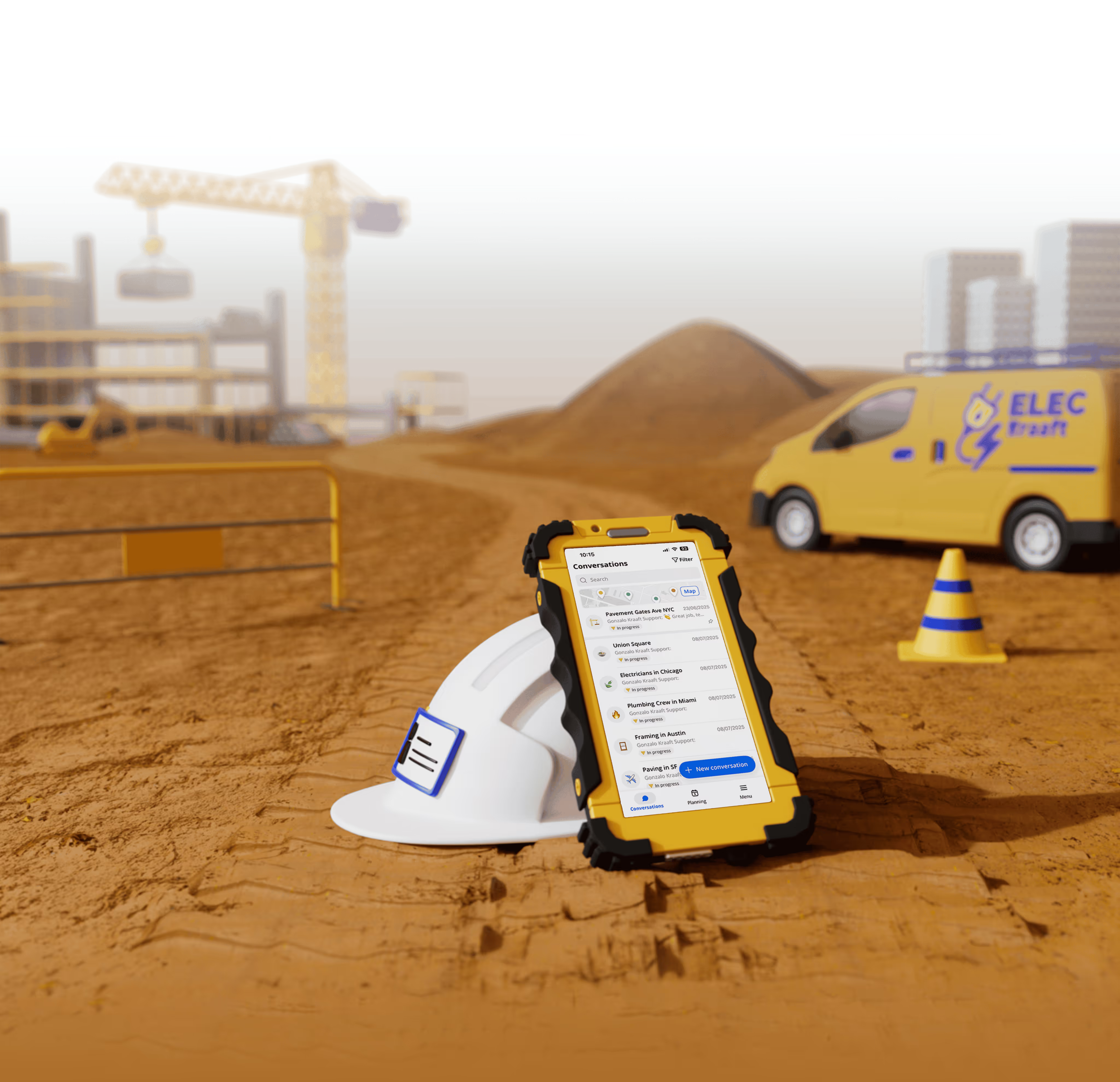
Real-time geotagged photo reporting
Every photo taken in Kraaft is automatically stamped with GPS coordinates, date, and time. For a ground improvement contractor, that means every pile position, every grout injection point, every soil anomaly is precisely located — automatically. No manual entry, no "I think it was around grid G7."
This is the same capability that helped crews at Coquitlam Ridge Constructors stay on top of documentation across a large, fast-moving site.
Structured forms that match your reporting requirements
Kraaft's forms builder lets you build custom templates that match exactly what your client, engineer, or quality system requires — pile driving logs, injection records, compaction test sheets, anomaly reports. Field crews fill them on-site from a phone or tablet. The data feeds directly into a PDF or Word export that's ready to share.
No reformatting. No transcription errors. No end-of-day data entry sprint.
Centralized channel communication per project
Each project gets its own workspace in Kraaft. Messages, photos, forms, and files all live in one place, organized by jobsite. When the project engineer in the office needs to see what's happening at rig #3, they open the channel — everything is there, in real time, with location.
For geotechnical contractors working across multiple simultaneous projects, this replaces the chaos of WhatsApp group threads that mix three projects, four subcontractors, and no searchable history.
Export-ready documentation for client handover
At the end of a phase or project, Kraaft generates reports from the data already captured in the field. No hunting for photos. No reconstructing a timeline from memory. The as-built documentation is built as you go.
The real cost of bad field documentation
Bad documentation doesn't just create audit headaches. For geotechnical contractors, it creates commercial exposure.
When unexpected ground conditions cause a project delay or cost overrun, your ability to recover that cost depends entirely on your documentation. Was the anomaly logged at the time? Is there a geolocated photo with a timestamp? Did the site manager notify the engineer in writing, and is that notification retrievable?
If the answer to any of those is "well, we think so, but it was on WhatsApp," you have a problem.
Good field reporting isn't overhead. It's how geotechnical contractors protect their margins.
Getting started
Kraaft works out of the box and is free to try. Field crews are typically up and running within a day — the interface is close enough to messaging apps that most workers don't need training.
If your team is still running on paper logs, WhatsApp, and end-of-day data entry, it's worth seeing what changes when the documentation happens in real time.
Watch a 3-minute demo of Kraaft →
Kraaft is used by geotechnical and ground improvement contractors across Europe and North America, including teams within the VINCI Construction group. The platform supports field communication and reporting in English, French, Spanish, German, and Italian.

Reconnect the site
and the office